


Aupillon et Pic de Boussolenc en 3 jours

Bastet
User
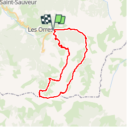

Length
30 km

Max alt
2884 m

Uphill gradient
2232 m
Km-Effort
59 km

Min alt
1439 m

Downhill gradient
2232 m
Boucle
Yes
Creation date :
2019-06-12 21:21:50.146
Updated on :
2019-06-28 16:10:47.627
8h30
Difficulty : Very difficult

FREE GPS app for hiking
 SityTrail
IGN / Geographical institutes
SityTrail Plus
The world is yours!
About
Trail Walking of 30 km to be discovered at Provence-Alpes-Côte d'Azur, Hautes-Alpes, Les Orres. This trail is proposed by Bastet.
Positioning
Country:
France
Region :
Provence-Alpes-Côte d'Azur
Department/Province :
Hautes-Alpes
Municipality :
Les Orres
Location:
Unknown
Start:(Dec)
Start:(UTM)
306795 ; 4931691 (32T) N.
Comments